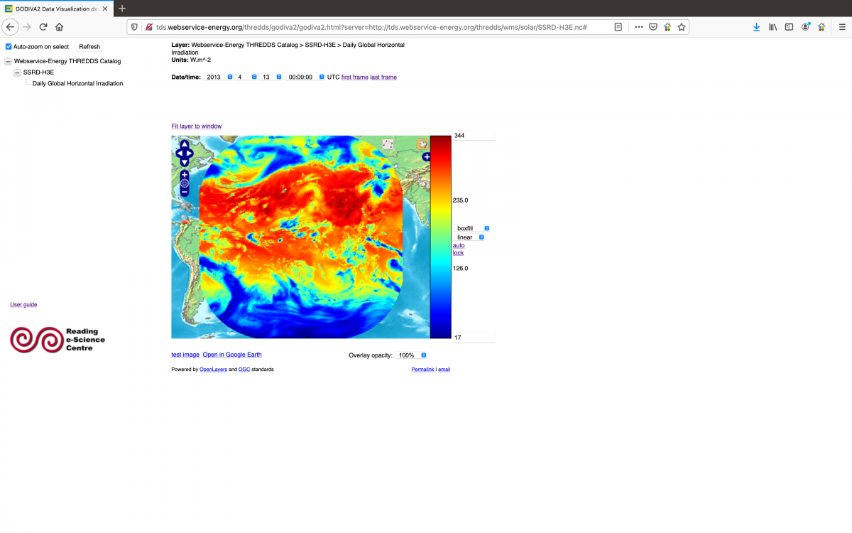
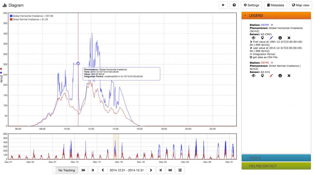
OGC

PACA Region (FRANCE) 250 m Irradiation Map (WMS)

This OGC Web Map Service (WMS) provides maps of annual Irradiation of the PACA (Provence Alpes Cote d'Azur) region in France at  a resolution of 250 m.

This include layers of:

  • PACA DNI (Direct Normal Irradiance) Mean Year Irradiation Map
  • PACA GHI (Global Horizontal Irradiance) Mean Year Irradiation Map
  • PACA GTI (Global Tilted Irradiance) at 35 degrees South Mean Year Irradiation Map

EnerGEO Catalogue:

Shadow (OGC WMS)

The Shadow OGC Web Map Service provides an estimation from SRTM v4 of the relief shadow effect on Solar Resource: loss in % of day duration, clear sky Global Horizontal Irradiance and clear sky Direct Normal Irradiance.

SRTM (OGC WMS)

The SRTM OGC Web Map Service  provides Digital Elevation Model (DEM) map from SRTM v4.

EnerGEO  Catalogue

energeo.researchstudio.at/geoportal/catalog/main/home.page

Get Capability URL:

http://www.webservice-energy.org/mapserv/srtm?service=WMS&request=GetCapabilities

Environmental Life Cycle Impact Assessment WPS

This OGC Web Processing Service (WPS) provides environmental life cycle impact assessment for the Photovoltaic (PV) Sector using various impact computation methods (Impact 2002+, CML 2001, Eco-Indicator 99, IPCC 2007 GWP).

It delivers both geo-localized Point Based Values and/or Map Based Area of Interest (AOI). Ecoinvent provides life cycle impact assessment for the photovoltaic systems database. Mines ParisTech provides Solar Radiation GHI from HelioClim3 database.

Resource Locator:

Australia Climate - Average daily solar exposure

The Australia Climate Web Map Service provides maps of averages of daily global solar irradiation received at ground level on a horizontal plane over Australia. Data for the period 1990 to 2008 are averaged to provide 12 maps of monthly means and a map of yearly mean of daily irradiation. Unit is MJ/m2.

Provider is the Bureau of Meteorology of Australia.

http://www.bom.gov.au/jsp/ncc/climate_averages/solar-exposure/index.jsp

Get Capability URL:

HC3 Map (OGC WMS)

The HC3Map Web Service provides maps of 5-years average of the monthly irradiation, i.e., the mean energy received during a whole month per square meter. Irradiation is expressed in kWh/m2. Period is 2004-2008. Two maps are provided: one for the global irradiation received on a horizontal plane (GHI), the other for the direct irradiation received on a plane always facing the sun (DNI). These maps are computed from irradiances of the HelioClim 3 database.

EnerGEO  Catalogue

HelioClim-1 Surface Solar Radiation

HelioClim-1 database contains 21 years of data (1985-2005). MINES ParisTech created HelioClim-1 by processing images from the Meteosat satellites. These data are of major interest for Africa, the Mediterranean Basin, and the Central Atlantic Ocean. They will provide valuable help for many applications, ranging from electricity production to climate studies.

HelioClim 3 (OGC WPS)

 The HelioClim 3 OGC Web Processing Service (WPS) gives access to irradiance values from the database HelioClim-3, computed from images of the Meteosat satellites since February 2004. Irradiation is expressed in kWh/m2. This service is presently limited to the year 2005. Provider: Ecole des Mines de Paris / Armines (France).

Resource Locator:

toolbox.webservice-energy.org/TOOLBOX/manager

Subscribe to OGC